Bicycles belong in wild places.
Bicycling and Wilderness
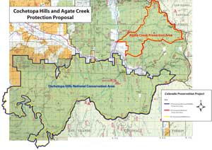
click image for full map (344 kb)
Cochetopa Hills & Agate Creek
(see separate description for Agate Creek)
Proposals:
Cochetopa Hills National Conservation Area
Cochetopa Hills Wildlife Protection Area
Agencies: USFS
Agency Status: normal multiple use area; inventoried roadless area
Counties: Saguache
Nearest City of Town: Gunnison
Location: southeast corner of Gunnison Basin; northernmost area of San Luis Basin
Description:
As the lowest point of the Continental Divide in Colorado the Cochetopa Hills create an important wildlife migration corridor between the East and West Slopes. The roadless area in the core of this corridor needs protection.
The land is heavily forested, without alpine terrain. and has not yet attracted large numbers of visitors. But the Cochetopa country includes a wealth of excellent singletrack trails used by a small but increasing number of cyclists. The Colorado Trail and Continental Divide National Scenic Trail are perched right on the Continental Divide ridgeline.
The designation for the Cochetopa Hills as both a National Consevation Area and a Wildlife Protection Area will mean that motorized users will be allowed to visit the area, subject to the same limits on numbers of visitors as muscle-powered users.