Bicycles belong in wild places.
Bicycling and Wilderness
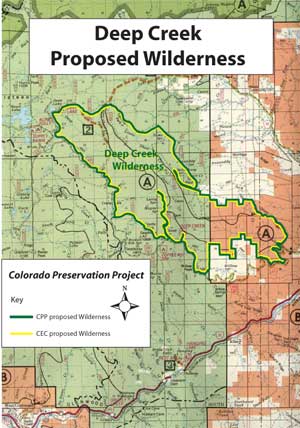
click image for full map (252 kb)
Deep Creek
Proposals:
Deep Creek Wilderness
Agencies: BLM and USFS
Counties: Garfield
Nearest City of Town: Gypsum
Location: Just north of I-70, Dotsero exit (#133); 3 mi. south of Flattops Wilderness boundary
Description:
The BLM and Forest Service have evaluated Deep Creek for protection under the federal Wild and Scenic Rivers Act. The creek emerges from Deep Lake near the Flat Tops Wilderness Area and flows southeast for 15 miles to empty into the Colorado River near Dotsero. In this short span, the stream plunges more than 4,500 feet, carving a steep canyon through the limestone strata. The water nurtures a great variety of plant life, giving the rugged canyon an almost delicate quality.
The native limestone is highly susceptible to cave formation, and there are over forty known caves in the area. These include Colorado’s longest cave, and others that are accessible only by scuba diving. The caverns further enhance the magical quality of this unique canyon.
While Deep Creek clearly is one of Colorado’s prime spots for spelunking, day hikers, backpackers, photographers and birdwatchers can also enjoy secluded and enchanting outings here. The canyon is too steep and narrow to make biking practical. Wilderness designation is the appropriate form of protection for Deep Creek.