Bicycles belong in wild places.
Bicycling and Wilderness
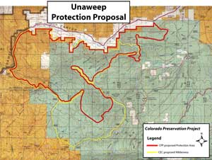
click image for full map (456 kb)
Unaweep
Proposals:
Unaweep National Protection Area
Agencies: BLM and USFS
Agency Status: none (a smaller wilderness proposal may be in the upcoming Forest Plan draft.)
Counties: Mesa
Nearest City or Town: Gateway and Whitewater
Location: On the Uncompaghre Plateau, south of the Unaweep Canyon highway (Colorado 141)
Description:
Unaweep encompasses a segment of the Uncompaghre Plateau’s western escarpment with a mixture of mesas, cliffs, and canyons This area includes a number of excellent trails suitable for many forms of recreation. The far west end, managed by BLM, has few trails and may be one of the more wild places in this proposal.
Prior to the 2002 Travel Management Plan, the Forest Service allowed motorized use on all trails in this area. When they curtailed that use through that plan, the agency also inexplicably banned bicycling. No reasons were stated and the Colorado Plateau Mountain Bike Trail Association asked the agency to re-visit the decision as soon as possible. That has not occurred.
The area is a 45-minute drive from Grand Junction and offers important recreation opportunities. This proposal will protect its natural values while also enhancing non-motorized recreation opportunities.
The CPP boundaries would further limit motorized travel in one place. The Snowshoe Trail (607), where it climbs from FSR 405 to FSR 416, is too steep to withstand the torque of motorcycles. It is extremely eroded. The CPP Unaweep National Protection Area proposal includes this trail and thus would close it to motors. An alternative approach would change either the boundaries or designation type, plus re-route and rebuild that trail to a motorized standard. That trail project would be quite expensive.